FREE shipping over $99.
Good Sam members: FREE shipping over $69. | Join Now
Shop Parts & Accessories For Your RV
Select your vehicle to get started

C-MAP 4D NA-D943 Cartography, Florida And The Bahamas
$189.99

Ship to Home
Delivery time calculated in checkout
Delivery time calculated in checkout
Free In-Store Pickup
Not Available
- This item is currently not available
Free Standard Shipping
This item is excluded from all discounts and promotions.
Minimum order quantity of
1
Maximum order quantity of
100
Must purchase in increments of
1

Shipping Restrictions
This item cannot be shipped internationally.
Return Policy
We believe in offering the very best value, quality, and selection. Plus, we want you to enjoy your purchase! In the event you wish to send a product back to us, you may return most unused items for a refund or exchange, minus shipping, within 90 days from the date of purchase unless noted below under exceptions and exclusions. Refunds are issued to the original form of payment, unless returned in store where some exclusions may apply.
Features
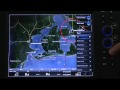
The next evolution in navigation solutions. C-MAP 4D adapts to your boating needs because it's the only digital chart that offers advanced features and lets you add data and services as they become available. 4D cartography is compatible with the Furuno 1670F / 1870F, and Standard CPN 7000i, and CPN1010i units. MicroSD/SD card format.
Features:
• 3D Chart View - The world has three dimensions. When you add the 4th dimension of time - meaning consistent, periodic updates - you combine the most detailed 3D height and depth worldwide database with a continuous update process to give you a personalized navigation experience with up-to-date data for safe navigation.
• High-Resolution Satellite Imagery - See the real world on your screen. C-MAP 4D includes a navigational perspective with high-resolution coastal imagery overlaid on the most accurate and up-to-date vector data, plus thousands of extraordinary photos for the most popular marinas and areas of interest.
• Digital Raster Charts - Innovate tradition. With raster charts, you have an additional reference source for navigational awareness. Get "at-a-glance" information using the nautical paper charts overlaid on the multi-dimensional shaded relief to have a new visual experience.
• Easy Routing - Automatically create a route. Enter start and end points along with specific boat parameters and automatically receive waypoints of the shortest route; highlights potential hazards and displays varying levels of alerts for each segment of the route, allows you to manually adjust the route.
• Guardian Alarm - An extra layer of safety. When activated, Guardian Alarm performs an automatic forward-scanning check for obstacles. Use the feature as an added backup to alert you should you head toward a potentially harmful object.
• Detailed NavAids
• Route Check
• Detailed Marina Charts
• C-Marina Ports Database
• Multi-Language Capability
• Dynamic Tides & Currents
• Photos & Diagrams
• Depths & Land Elevations
• Perspective View
- Revolutionary navigation solution
- Easily upgraded with new data
- High resolution satellite imagery
- Easy routing
- Detailed marina charts
Specs
Unit Weight
0.10 lb
Brand
C-MAP
MFG Part No.
50312
 800-700-1366